|
|
Antenna Structure Registration 1210879 |
 |
Registration Info | Registration Number: 1210879 |
| File Number: A1316602 |
| FAA Study: 2012-ASO-7110-OE |
| FAA Issue Date: 08/15/2012 |
| Status: Constructed |
| Date Constructed: 08/24/2012 |
| FAA EMI: N |
| NEPA: N |
Structure Info
| Structure Type: LTOWER |
| Structure Coordinates: 28-32-23.4 N 82-4-47.5 W (NAD 83) |
| Structure Coordinates: 28-32-22.4 N 82-04-48.2 W (Converted to NAD 27) |
| Structure Address: 1 Mile Sse Of Wilson Corner |
| Structure City: Tarrytown, FL |
| Structure County: Sumter County |
| Painting & Lighting Info |
FAA Circular #: 70/7460-1K |
FAA Chapters: 4, 6, 12 |
Remarks: OM&L to remain the same as prior study = 24-HR MED-STROBES |
Remarks: PRIOR STUDY 2004-ASO-3907-OE |
Remarks: OM&L to remain the same as prior study = 24-HR MED-STROBES |
Remarks: PRIOR STUDY 2004-ASO-3907-OE |
| Elevation Info |
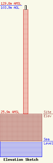
Site Elevation: 25.9 meters (85 ft) |
| Height of Structure: 100 meters (328 feet) |
| Overall Height Above Ground: 103.9 meters (341 feet) |
| Overall Height Above Mean Sea Level: 129.8 meters (426 feet) |
| Owner Info | Sumter Communications, Inc
1227
Dade City, FL 33526-1227
(352) 567-6146
wstubbs@embarqmail.com |
| Contact Info | Sumter Communications, Inc
1227
Dade City, FL 33526-1227
(352) 567-6146
wstubbs@embarqmail.com |
