|
|
Antenna Structure Registration 1230855 |
 |
Registration Info | Registration Number: 1230855 |
| File Number: A1358380 |
| FAA Study: 2025-AGL-12390-OE |
| FAA Issue Date: 10/07/2025 |
| Status: Constructed |
| Date Constructed: 11/09/2000 |
Structure Info
| Structure Type: GTOWER |
| Structure Coordinates: 46-36-15.4 N 87-37-15.1 W (NAD 83) |
| Structure Coordinates: 46-36-15.6 N 87-37-14.6 W (Converted to NAD 27) |
| Structure Address: 1005 County Road 510 |
| Structure City: Negaunee, MI |
| Structure County: Marquette County |
| Painting & Lighting Info |
FAA Circular #: 70/7460-1M |
FAA Chapters: 4, 8, 15 |
Remarks: PRIOR STUDY 2001-AGL-4969-OE |
| Elevation Info |
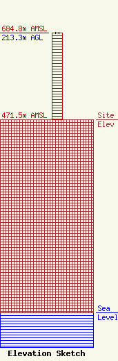
Site Elevation: 471.5 meters (1547 ft) |
| Height of Structure: 213.3 meters (700 feet) |
| Overall Height Above Ground: 213.3 meters (700 feet) |
| Overall Height Above Mean Sea Level: 684.8 meters (2247 feet) |
| Owner Info | Tarpon Towers III, LLC
8916 77th Terrace East
34202
Lakewood Ranch, FL 34202
(941) 757-5010
tbowman@tarpontowers.com |
| Contact Info | Tarpon Towers III, LLC
8916 77th Terrace East
34202
Lakewood Ranch, FL 34202
Todd Bowman
(941) 757-5010
tbowman@tarpontowers.com |
