|
|
Antenna Structure Registration 1250130 |
 |
Registration Info | Registration Number: 1250130 |
| File Number: A1376786 |
| FAA Study: 2005-ASO-4531-OE |
| FAA Issue Date: 09/12/2005 |
| Status: Constructed |
| Date Constructed: 12/16/2005 |
| NEPA: N |
Structure Info
|
| Structure Coordinates: 37-4-36.3 N 84-48-38.8 W (NAD 83) |
| Structure Coordinates: 37-04-36.0 N 84-48-39.0 W (Converted to NAD 27) |
| Structure Address: 1 Km Nw Of Intersection Of Hwy 196 And Hwy 1664 |
| Structure City: Somerset, KY |
| Structure County: Pulaski County |
| Painting & Lighting Info |
FAA Circular #: 70/7460-1K |
FAA Chapters: 3, 4, 5, 12 |
| Elevation Info |
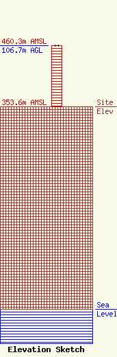
Site Elevation: 353.6 meters (1160 ft) |
| Height of Structure: 106.7 meters (350 feet) |
| Overall Height Above Ground: 106.7 meters (350 feet) |
| Overall Height Above Mean Sea Level: 460.3 meters (1510 feet) |
| Owner Info | K-LOVE, Inc.
2000 Reams Fleming Boulevard
Franklin, TN 37064
(916) 251-1600
fccdocumentdistribution@emfbroadcasting.com |
| Contact Info | K-LOVE, Inc.
2000 Reams Fleming Boulevard
Franklin, TN 37064
(916) 251-1600
fccdocumentdistribution@emfbroadcasting.com |
