|
|
Antenna Structure Registration 1213205 |
 |
Registration Info | Registration Number: 1213205 |
| File Number: A0196712 |
| FAA Study: 99-AGL-6500-OE |
| Status: Constructed |
| Date Constructed: 08/18/1980 |
| FAA EMI: N |
| NEPA: N |
Structure Info
| Structure Type: TOWER |
| Structure Coordinates: 43-33-42.1 N 83-58-51.9 W (NAD 83) |
| Structure Coordinates: 43-33-42.0 N 83-58-52.0 W (Converted to NAD 27) |
| Structure Address: Delta Road 5.5 Miles Sw Of Bay City |
| Structure City: University Center, MI |
| Structure County: Bay County |
| Painting & Lighting Info |
FCC Paragraph(s): 1, 3, 4, 13, 21 |
| Elevation Info |
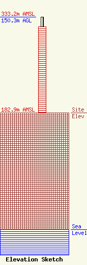
Site Elevation: 182.9 meters (600 ft) |
| Height of Structure: 134.8 meters (442 feet) |
| Overall Height Above Ground: 150.3 meters (493 feet) |
| Overall Height Above Mean Sea Level: 333.2 meters (1093 feet) |
| Owner Info | Delta College
1961 Delta Road
University Center, MI 48710
(517) 686-9357
tggarnet@alpha.delta.edu |
