|
|
Antenna Structure Registration 1034778 |
 |
Registration Info | Registration Number: 1034778 |
| File Number: A1349902 |
| FAA Study: 2021-ASW-215-OE |
| FAA Issue Date: 03/02/2021 |
| Status: Constructed |
| Date Constructed: 12/01/1999 |
| NEPA: N |
Structure Info
| Structure Type: GTOWER |
| Structure Coordinates: 33-32-26.0 N 91-22-41.4 W (NAD 83) |
| Structure Coordinates: 33-32-25.6 N 91-22-41.0 W (Converted to NAD 27) |
| Structure Address: E Side Of Us Hwy 165 6.1 Km Ne |
| Structure City: Dermott, AR |
| Structure County: Chicot County |
| Painting & Lighting Info |
FAA Circular #: 70/7460-1M |
FAA Chapters: 4, 8, 15 |
Remarks: PRIOR STUDY 1997-ASW-1607-OE |
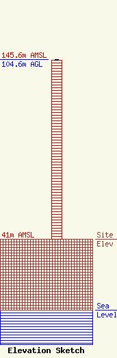
| Elevation Info |
Site Elevation: 41 meters (135 ft) |
| Height of Structure: 104 meters (341 feet) |
| Overall Height Above Ground: 104.6 meters (343 feet) |
| Overall Height Above Mean Sea Level: 145.6 meters (478 feet) |
| Owner Info | K-LOVE, Inc.
2000 Reams Fleming Boulevard
37064
Franklin, TN 37064
(916) 251-1600
fccdocumentdistribution@emfbroadcasting.com |
| Contact Info | K-LOVE, Inc.
2000 Reams Fleming Boulevard
37064
Franklin, TN 37064
(916) 251-1600
fccdocumentdistribution@emfbroadcasting.com |
