|
|
Antenna Structure Registration 1056397 |
 |
Registration Info | Registration Number: 1056397 |
| File Number: A0066302 |
| FAA Study: 98-AEA-1561-OE |
| FAA Issue Date: 08/26/1998 |
| Status: Constructed |
| Date Constructed: 01/01/1985 |
| NEPA: N |
Structure Info
| Structure Type: TOWER |
| Structure Coordinates: 40-30-20.0 N 78-48-11.0 W (NAD 83) |
| Structure Coordinates: 40-30-19.7 N 78-48-11.9 W (Converted to NAD 27) |
| Structure Address: 1800' East Of Pindleton On Us Route #422 |
| Structure City: Nanty Glo, PA |
| Structure County: Cambria County |
| Painting & Lighting Info |
FAA Chapters: NONE |
| Elevation Info |
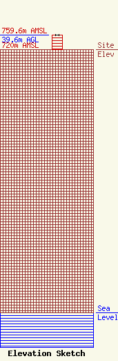
Site Elevation: 720 meters (2362 ft) |
| Height of Structure: 39.6 meters (130 feet) |
| Overall Height Above Ground: 39.6 meters (130 feet) |
| Overall Height Above Mean Sea Level: 759.6 meters (2492 feet) |
| Owner Info | SUMRADA COMMUNICATIONS SERVICE
138 LINTNER AVE.
JOHNSTOWN, PA 15902
(814) 535-6155
|
