|
|
Antenna Structure Registration 1267365 |
 |
Registration Info | Registration Number: 1267365 |
| File Number: A0654212 |
| FAA Study: 2009-ASO-538-OE |
| FAA Issue Date: 02/24/2009 |
| Status: Constructed |
| Date Constructed: 07/20/2009 |
| FAA EMI: N |
| NEPA: N |
Structure Info
| Structure Type: TOWER |
| Structure Coordinates: 36-15-28.8 N 88-11-11.1 W (NAD 83) |
| Structure Coordinates: 36-15-28.6 N 88-11-11.0 W (Converted to NAD 27) |
| Structure Address: 7324 Hwy 69 S |
| Structure City: Paris, TN |
| Structure County: Henry County |
| Painting & Lighting Info |
FAA Circular #: 70/7460-1K |
FAA Chapters: 4, 8, 12 |
Remarks: Removed expiration date from determination. Scenario 1./jjs/case#635066 |
| Elevation Info |
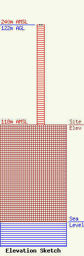
Site Elevation: 118 meters (387 ft) |
| Height of Structure: 122 meters (400 feet) |
| Overall Height Above Ground: 122 meters (400 feet) |
| Overall Height Above Mean Sea Level: 240 meters (787 feet) |
| Owner Info | AMERICAN FAMILY ASSOCIATION
P.O. DRAWER 2440
TUPELO, MS 38803
(662) 844-8888
JES@AFA.NET |
