|
|
Antenna Structure Registration 1238861 |
 |
Registration Info | Registration Number: 1238861 |
| File Number: A1351146 |
| FAA Study: 2025-ASO-17944-OE |
| FAA Issue Date: 10/10/2025 |
| Status: Constructed |
| Date Constructed: 06/20/2004 |
| NEPA: N |
Structure Info
| Structure Type: GTOWER |
| Structure Coordinates: 32-42-51.5 N 89-49-19.2 W (NAD 83) |
| Structure Coordinates: 32-42-51.0 N 89-49-18.9 W (Converted to NAD 27) |
| Structure Address: On Sulphur Spring Rd, 1/2 Mile West Of Sr 17 & 2 Miles South Of Sr 43 Ms-5087 |
| Structure City: Canton, MS |
| Structure County: Madison County |
| Painting & Lighting Info |
FAA Circular #: 70/7460-1M |
FAA Chapters: 4, 8, 15 |
Remarks: PRIOR STUDY 2004-ASO-3967-OE |
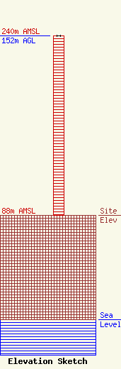
| Elevation Info |
Site Elevation: 88 meters (289 ft) |
| Height of Structure: 152 meters (499 feet) |
| Overall Height Above Ground: 152 meters (499 feet) |
| Overall Height Above Mean Sea Level: 240 meters (787 feet) |
| Owner Info | VB-S1 Assets, LLC
22 W Atlantic Avenue
Delray Beach, FL 33444
(561) 406-4015
fcc-faa@verticalbridge.com |
| Contact Info | VB-S1 Assets, LLC
22 W Atlantic Avenue
Delray Beach, FL 33444
Richard Hickey
(561) 406-4015
fcc-faa@verticalbridge.com |
