|
|
Antenna Structure Registration 1030015 |
 |
Registration Info | Registration Number: 1030015 |
| File Number: A0677368 |
| FAA Study: 96-ASO-4071-OE |
| FAA Issue Date: 09/17/1996 |
| Status: Constructed |
| Date Constructed: 11/01/1990 |
| FAA EMI: N |
| NEPA: N |
Structure Info
| Structure Type: BANT |
| Structure Coordinates: 25-43-57.0 N 80-14-3.0 W (NAD 83) |
| Structure Coordinates: 25-43-55.6 N 80-14-03.8 W (Converted to NAD 27) |
| Structure Address: 2601 South Bayshore Drive |
| Structure City: Coconut Grove, FL |
| Structure County: Miami-Dade County |
| Painting & Lighting Info |
FAA Circular #: 70/7460-1J |
FAA Chapters: 4, 5, 13 |
| Elevation Info |
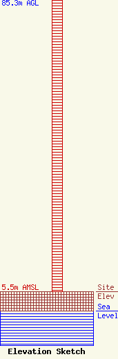
Site Elevation: 5.5 meters (18 ft) |
| Height of Structure: 85.3 meters (280 feet) |
| Overall Height Above Ground: 85.3 meters (280 feet) |
| Overall Height Above Mean Sea Level: 90.8 meters (298 feet) |
| Owner Info | Spanish Broadcasting System of Florida, Inc
2601 South Bayshore Dr, Penthouse 2
Coconut Grove, FL 33133
(305) 444-9292
|
| Info |
