|
|
Antenna Structure Registration 1031019 |
 |
Registration Info | Registration Number: 1031019 |
| File Number: A0195447 |
| FAA Study: 91-AGL-1492-OE |
| FAA Issue Date: 10/29/1991 |
| Status: Granted |
| Date Constructed: 07/01/1955 |
| FAA EMI: N |
| NEPA: N |
Structure Info
| Structure Type: TOWER |
| Structure Coordinates: 37-56-3.1 N 87-55-35.1 W (NAD 83) |
| Structure Coordinates: 37-56-02.9 N 87-55-35.0 W (Converted to NAD 27) |
| Structure Address: 601 Upton Rd |
| Structure City: Mount Vernon, IN |
| Structure County: Posey County |
| Painting & Lighting Info |
FAA Chapters: NONE |
| Elevation Info |
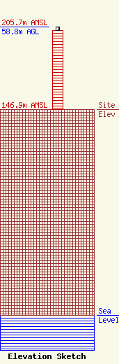
Site Elevation: 146.9 meters (482 ft) |
| Height of Structure: 56.3 meters (185 feet) |
| Overall Height Above Ground: 58.8 meters (193 feet) |
| Overall Height Above Mean Sea Level: 205.7 meters (675 feet) |
| Owner Info | The Original Company, Inc.
1309 Old Orchard Road
PO Box 242
Vincennes, IN 46571-0242
(812) 882-6060
|
| Contact Info | Mark R. Lange
1309 Old Orchard Road
PO Box 242
Vincennes, IN 47591-0242
Mark Lange
(812) 882-6060
|
