|
|
Antenna Structure Registration 1044649 |
 |
Registration Info | Registration Number: 1044649 |
| File Number: A0052683 |
| FAA Study: 88-ASO-72-OE |
| FAA Issue Date: 04/12/1988 |
| Status: Constructed |
| Date Constructed: 01/01/1988 |
| NEPA: N |
Structure Info
| Structure Type: TOWER |
| Structure Coordinates: 36-48-31.0 N 88-13-26.0 W (NAD 83) |
| Structure Coordinates: 36-48-30.8 N 88-13-25.9 W (Converted to NAD 27) |
| Structure Address: 2 Km E Of St Rt 1364 4.5 Km S Of Us 68 |
| Structure City: Fairdealing, KY |
| Structure County: Marshall County |
| Painting & Lighting Info |
FAA Circular #: 70/7460-1G |
FAA Chapters: 3, 4, 5, 9 |
| Elevation Info |
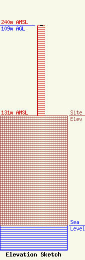
Site Elevation: 131 meters (430 ft) |
| Height of Structure: 108 meters (354 feet) |
| Overall Height Above Ground: 109 meters (358 feet) |
| Overall Height Above Mean Sea Level: 240 meters (787 feet) |
| Owner Info | HEARTLAND MINISTRIES INC WVHM
281
HARDIN, KY 42048
(502) 437-4095
|
