|
|
Antenna Structure Registration 1051226 |
 |
Registration Info | Registration Number: 1051226 |
| File Number: A0060345 |
| FAA Study: 98-ASO-2786-OE |
| FAA Issue Date: 06/09/1998 |
| Status: Granted |
| FAA EMI: Y |
| NEPA: N |
Structure Info
| Structure Type: TOWER |
| Structure Coordinates: 32-38-37.0 N 88-40-29.0 W (NAD 83) |
| Structure Coordinates: 32-38-36.5 N 88-40-28.8 W (Converted to NAD 27) |
| Structure Address: Approx 16.1km (10mi) South Of Dekalb, Ms Near The Community Of Blackwater |
| Structure City: Blackwater, MS |
| Structure County: Kemper County |
| Painting & Lighting Info |
FAA Circular #: 70/7460-1J |
FAA Chapters: 3, 4, 5, 13 |
Remarks: Removed expiration date from determination. Scenario 1./jjs/case#635066 |
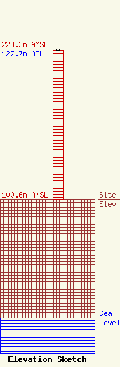
| Elevation Info |
Site Elevation: 100.6 meters (330 ft) |
| Height of Structure: 126.7 meters (416 feet) |
| Overall Height Above Ground: 127.7 meters (419 feet) |
| Overall Height Above Mean Sea Level: 228.3 meters (749 feet) |
| Owner Info | EAST MISSISSIPPI BROADCASTERS, INC.
3436 HWY 45 NORTH
1699
MERIDIAN, MS 39302
(601) 693-2661
|
