|
|
Antenna Structure Registration 1043534 |
 |
Registration Info | Registration Number: 1043534 |
| File Number: A1276224 |
| FAA Study: 94-AGL-2509-OE |
| FAA Issue Date: 06/03/1994 |
| Status: Constructed |
| Date Constructed: 07/01/1995 |
| FAA EMI: N |
| NEPA: N |
Structure Info
| Structure Type: TOWER |
| Structure Coordinates: 38-24-25.0 N 82-33-40.0 W (NAD 83) |
| Structure Coordinates: 38-24-24.7 N 82-33-40.4 W (Converted to NAD 27) |
| Structure Address: 0.6 Mi E Of The N & W Railroad Crossing |
| Structure City: South Point, OH |
| Structure County: Lawrence County |
| Painting & Lighting Info |
FAA Chapters: NONE |
| Elevation Info |
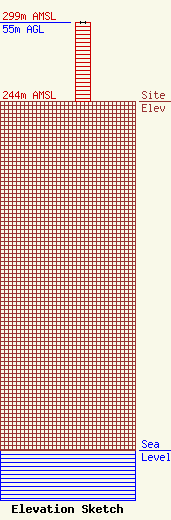
Site Elevation: 244 meters (801 ft) |
| Height of Structure: 55 meters (180 feet) |
| Overall Height Above Ground: 55 meters (180 feet) |
| Overall Height Above Mean Sea Level: 299 meters (981 feet) |
| Owner Info | Kindred Communications, Inc.
555 Fifth Avenue
Huntington, WV 25701
(304) 523-8401
mikek@kindredcom.net |
| Contact Info | Shainis & Peltzman, Chartered
1850 M Street, NW
Washington, DC 20036
Susan Marshall
(202) 293-0011
susan@s-plaw.com |
