|
|
Antenna Structure Registration 1015364 |
 |
Registration Info | Registration Number: 1015364 |
| File Number: A0018370 |
| FAA Study: 88-AGL-1709-OE |
| FAA Issue Date: 11/30/1988 |
| Status: Constructed |
| Date Constructed: 02/01/1997 |
| NEPA: N |
Structure Info
| Structure Type: TOWER |
| Structure Coordinates: 40-50-10.0 N 83-14-11.0 W (NAD 83) |
| Structure Coordinates: 40-50-09.8 N 83-14-11.3 W (Converted to NAD 27) |
| Structure Address: 10779 Twp Rd 122 |
| Structure City: Upper Sandusky, OH |
| Structure County: Wyandot County |
| Painting & Lighting Info |
FAA Circular #: 70/7460-1G |
FAA Chapters: 3, 4, 5, 9 |
| Elevation Info |
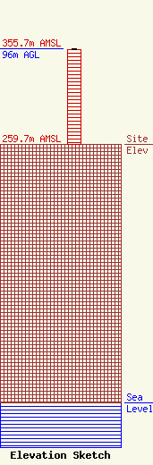
Site Elevation: 259.7 meters (852 ft) |
| Height of Structure: 95 meters (312 feet) |
| Overall Height Above Ground: 96 meters (315 feet) |
| Overall Height Above Mean Sea Level: 355.7 meters (1167 feet) |
| Owner Info | KAYSER BROADCAST MINISTRIES INC DBA = WXML
10779 TWP RD 122
UPPER SANDUSKY, OH 43351
(419) 291-2900
|
