|
|
Antenna Structure Registration 1229102 |
 |
Registration Info | Registration Number: 1229102 |
| File Number: A0980966 |
| FAA Study: 01-ANM-2580-OE |
| FAA Issue Date: 08/15/2001 |
| Status: Constructed |
| Date Constructed: 08/31/1999 |
| FAA EMI: N |
| NEPA: N |
Structure Info
| Structure Type: TOWER |
| Structure Coordinates: 42-17-56.0 N 122-45-0.0 W (NAD 83) |
| Structure Coordinates: 42-17-56.5 N 122-44-55.9 W (Converted to NAD 27) |
| Structure Address: Mt. Baldy |
| Structure City: Medford, OR |
| Structure County: Jackson County |
| Painting & Lighting Info |
FAA Chapters: NONE |
Remarks: Removed expiration date from determination. Scenario 1./jjs/case#635066 |
| Elevation Info |
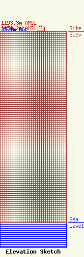
Site Elevation: 1158.2 meters (3800 ft) |
| Height of Structure: 29.3 meters (96 feet) |
| Overall Height Above Ground: 35.1 meters (115 feet) |
| Overall Height Above Mean Sea Level: 1193.3 meters (3915 feet) |
| C/R Height Above Mean Sea Level: 1186.2 meters (3892 ft)
|
| Owner Info | Mount Baldy Communication Site Leasing, LLC
3959 Old Stage Rd.
Central Point, OR 97502
(541) 664-1033
jsafley499@aol.com |
| Contact Info | Mount Baldy Communication Site Leasing, LLC
3959 Old Stage Rd.
Central Point, OR 97502
Gary Safley
(541) 664-1033
jsafley499@aol.com |
