|
|
Antenna Structure Registration 1207386 |
 |
Registration Info | Registration Number: 1207386 |
| File Number: A1085440 |
| FAA Study: 2017-AGL-7647-OE |
| FAA Issue Date: 06/19/2017 |
| Status: Constructed |
| Date Constructed: 09/21/1992 |
Structure Info
| Structure Type: GTOWER |
| Structure Coordinates: 39-45-20.6 N 87-42-49.8 W (NAD 83) |
| Structure Coordinates: 39-45-20.5 N 87-42-49.7 W (Converted to NAD 27) |
| Structure Address: 13640 East County Road (202566) |
| Structure City: Edgar, IL |
| Structure County: Edgar County |
| Painting & Lighting Info |
FAA Circular #: 70/7460-1L |
FAA Chapters: 4, 8, 12 |
Remarks: PRIOR STUDY 1992-AGL-1081-OE |
| Elevation Info |
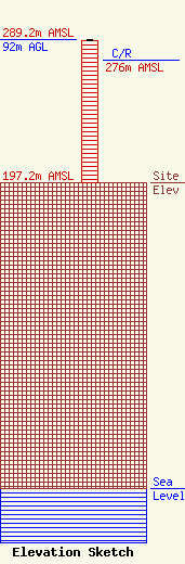
Site Elevation: 197.2 meters (647 ft) |
| Height of Structure: 91.4 meters (300 feet) |
| Overall Height Above Ground: 92 meters (302 feet) |
| Overall Height Above Mean Sea Level: 289.2 meters (949 feet) |
| C/R Height Above Mean Sea Level: 276 meters (906 ft)
|
| Owner Info | American Towers LLC
10 Presidential Way
Woburn, MA 01801
(781) 926-4500
faa-fcc@americantower.com |
| Contact Info | American Towers, LLC
10 Presidential Way
Woburn, MA 01801
(781) 926-4500
faa-fcc@americantower.com |
