|
|
Antenna Structure Registration 1007179 |
 |
Registration Info | Registration Number: 1007179 |
| File Number: A0008564 |
| Status: Constructed |
| Date Constructed: 01/23/1979 |
| NEPA: N |
Structure Info
| Structure Type: B |
| Structure Coordinates: 42-15-46.0 N 71-47-59.0 W (NAD 83) |
| Structure Coordinates: 42-15-45.7 N 71-48-00.7 W (Converted to NAD 27) |
| Structure Address: Bank Of Boston Twr 100 Front St |
| Structure City: Worcester, MA |
| Structure County: Worcester County |
| Painting & Lighting Info |
FCC Paragraph(s): None |
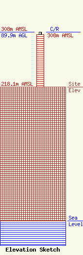
| Elevation Info |
Site Elevation: 218.1 meters (716 ft) |
| Height of Structure: 85.3 meters (280 feet) |
| Overall Height Above Ground: 89.9 meters (295 feet) |
| Overall Height Above Mean Sea Level: 308 meters (1010 feet) |
| C/R Height Above Mean Sea Level: 308 meters (1010 ft)
|
| Owner Info | WCUW INC
910 MAIN ST
WORCESTER, MA 01610-1433
(508) 753-1012
|
