|
|
Antenna Structure Registration 1211717 |
 |
Registration Info | Registration Number: 1211717 |
| File Number: A1225175 |
| FAA Study: 2022-ANM-4997-OE |
| FAA Issue Date: 10/13/2022 |
| Status: Constructed |
| Date Constructed: 03/20/2000 |
| NEPA: N |
Structure Info
| Structure Type: LTOWER |
| Structure Coordinates: 46-10-16.1 N 119-12-11.9 W (NAD 83) |
| Structure Coordinates: 46-10-16.6 N 119-12-07.8 W (Converted to NAD 27) |
| Structure Address: Brinkly Road |
| Structure City: Kennewick, WA |
| Structure County: Benton County |
| Painting & Lighting Info |
FAA Chapters: NONE |
Remarks: PRIOR STUDY 2012-ANM-3316-OE |
| Elevation Info |
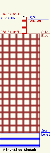
Site Elevation: 268.5 meters (881 ft) |
| Height of Structure: 45.7 meters (150 feet) |
| Overall Height Above Ground: 48.1 meters (158 feet) |
| Overall Height Above Mean Sea Level: 316.6 meters (1039 feet) |
| C/R Height Above Mean Sea Level: 308 meters (1010 ft)
|
| Owner Info | American Towers LLC
10 Presidential Way
Woburn, MA 01801
(781) 926-4500
faa-fcc@americantower.com |
| Contact Info | American Towers LLC
10 Presidential Way
Woburn, MA 01801
(781) 926-4500
faa-fcc@americantower.com |
