|
|
Antenna Structure Registration 1000195 |
 |
Registration Info | Registration Number: 1000195 |
| File Number: A1150172 |
| FAA Study: 2019-AGL-9467-OE |
| FAA Issue Date: 10/02/2019 |
| Status: Constructed |
| Date Constructed: 02/08/2001 |
| NEPA: N |
Structure Info
| Structure Type: GTOWER |
| Structure Coordinates: 45-46-47.0 N 87-8-25.7 W (NAD 83) |
| Structure Coordinates: 45-46-47.1 N 87-08-25.2 W (Converted to NAD 27) |
| Structure Address: 944 Fire #4565 17th Road (120005523 Escanaba) |
| Structure City: Escanaba, MI |
| Structure County: Delta County |
| Painting & Lighting Info |
FAA Circular #: 70/7460-1L |
FAA Chapters: 4, 8, 12 |
Remarks: PRIOR STUDY 2003-AGL-2627-OE |
| Elevation Info |
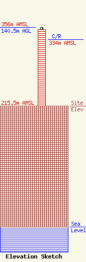
Site Elevation: 215.5 meters (707 ft) |
| Height of Structure: 136.9 meters (449 feet) |
| Overall Height Above Ground: 140.5 meters (461 feet) |
| Overall Height Above Mean Sea Level: 356 meters (1168 feet) |
| C/R Height Above Mean Sea Level: 334 meters (1096 ft)
|
| Owner Info | Alltel Corporation
5055 North Point Pkwy
Alpharetta, GA 30022
(770) 797-1070
Network.Regulatory@verizonwireless.com |
| Contact Info | Alltel Corporation
5055 North Point Pkwy
Alpharetta, GA 30022
Regulatory Manager
(770) 797-1070
Network.Regulatory@verizonwireless.com |
