|
|
Antenna Structure Registration 1022797 |
 |
Registration Info | Registration Number: 1022797 |
| File Number: A1320608 |
| FAA Study: 97-AEA-0719-OE |
| FAA Issue Date: 05/13/1997 |
| Status: Constructed |
| Date Constructed: 06/20/1996 |
| FAA EMI: N |
| NEPA: N |
Structure Info
| Structure Type: TOWER |
| Structure Coordinates: 38-57-58.0 N 78-26-31.0 W (NAD 83) |
| Structure Coordinates: 38-57-57.6 N 78-26-32.0 W (Converted to NAD 27) |
| Structure Address: 1181 Mount Olive Rd |
| Structure City: Toms Brook, VA |
| Structure County: Shenandoah County |
| Painting & Lighting Info |
FAA Circular #: 70/7460-1J |
FAA Chapters: 4, 8, 13 |
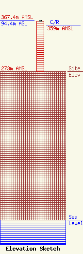
| Elevation Info |
Site Elevation: 273 meters (896 ft) |
| Height of Structure: 92.9 meters (305 feet) |
| Overall Height Above Ground: 94.4 meters (310 feet) |
| Overall Height Above Mean Sea Level: 367.4 meters (1205 feet) |
| C/R Height Above Mean Sea Level: 359 meters (1178 ft)
|
| Owner Info | VB-S1 Assets, LLC
22 W Atlantic Ave Suite 310
Delray Beach, FL 33444
(561) 405-4015
fcc-faa@verticalbridge.com |
| Contact Info | VB-S1 Assets, LLC
22 W Atlantic Ave Suite 310
Delray Beach, FL 33444
Richard Hickey
(561) 405-4015
fcc-faa@verticalbridge.com |
