|
|
Antenna Structure Registration 1210658 |
 |
Registration Info | Registration Number: 1210658 |
| File Number: A1302824 |
| FAA Study: 2024-AGL-14191-OE |
| FAA Issue Date: 10/24/2024 |
| Status: Constructed |
| Date Constructed: 06/30/2000 |
| NEPA: N |
Structure Info
| Structure Type: GTOWER |
| Structure Coordinates: 44-18-30.6 N 93-55-52.4 W (NAD 83) |
| Structure Coordinates: 44-18-30.7 N 93-55-51.6 W (Converted to NAD 27) |
| Structure Address: 33169 County Rd. 107 (st. Peter #009295) |
| Structure City: Saint Peter, MN |
| Structure County: Le Sueur County |
| Painting & Lighting Info |
FAA Circular #: 70/7460-1J |
FAA Chapters: 4, 8, 13 |
Remarks: OM&L to remain the same as prior study = A MED-DUAL SYSTEM |
Remarks: PRIOR STUDY 2007-AGL-6979-OE |
Remarks: OM&L to remain the same as prior study = A MED-DUAL SYSTEM |
Remarks: PRIOR STUDY 2007-AGL-6979-OE |
| Elevation Info |
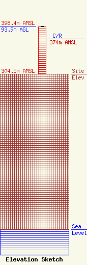
Site Elevation: 304.5 meters (999 ft) |
| Height of Structure: 92.7 meters (304 feet) |
| Overall Height Above Ground: 93.9 meters (308 feet) |
| Overall Height Above Mean Sea Level: 398.4 meters (1307 feet) |
| C/R Height Above Mean Sea Level: 374 meters (1227 ft)
|
| Owner Info | American Towers LLC
10 Presidential Way
Woburn, MA 01801
(781) 926-4500
faa-fcc@americantower.com |
| Contact Info | American Towers LLC
10 Presidential Way
Woburn, MA 01801
(781) 926-4500
faa-fcc@americantower.com |
