|
|
Antenna Structure Registration 1050708 |
 |
Registration Info | Registration Number: 1050708 |
| File Number: A1231367 |
| FAA Study: 2021-ASW-20379-OE |
| FAA Issue Date: 11/08/2022 |
| Status: Constructed |
| Date Constructed: 02/28/1987 |
| NEPA: N |
Structure Info
| Structure Type: GTOWER |
| Structure Coordinates: 33-9-23.6 N 96-42-47.9 W (NAD 83) |
| Structure Coordinates: 33-09-23.2 N 96-42-46.9 W (Converted to NAD 27) |
| Structure Address: 3853 County Road 154 (allen 2 #90353) |
| Structure City: Mc Kinney, TX |
| Structure County: Collin County |
| Painting & Lighting Info |
FAA Circular #: 70/7460-1G |
FAA Chapters: 4, 6, 9 |
Remarks: OM&L to remain the same as prior study = 24-HR HI-STROBES |
Remarks: PRIOR STUDY 2009-ASW-6080-OE |
Remarks: OM&L to remain the same as prior study = 24-HR HI-STROBES |
Remarks: PRIOR STUDY 2009-ASW-6080-OE |
| Elevation Info |
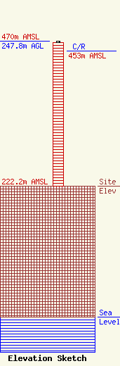
Site Elevation: 222.2 meters (729 ft) |
| Height of Structure: 245.1 meters (804 feet) |
| Overall Height Above Ground: 247.8 meters (813 feet) |
| Overall Height Above Mean Sea Level: 470 meters (1542 feet) |
| C/R Height Above Mean Sea Level: 453 meters (1486 ft)
|
| Owner Info | American Towers, LLC
10 Presidential Way
Woburn, MA 01801
(781) 926-4500
faa-fcc@americantower.com |
| Contact Info | American Towers, LLC
10 Presidential Way
Woburn, MA 01801
(781) 926-4500
faa-fcc@americantower.com |
