|
|
Antenna Structure Registration 1049723 |
 |
Registration Info | Registration Number: 1049723 |
| File Number: A1301192 |
| FAA Study: 2024-AGL-13456-OE |
| FAA Issue Date: 10/01/2024 |
| Status: Constructed |
| Date Constructed: 01/01/1987 |
| NEPA: N |
Structure Info
| Structure Type: GTOWER |
| Structure Coordinates: 44-17-20.7 N 84-44-32.4 W (NAD 83) |
| Structure Coordinates: 44-17-20.6 N 84-44-32.3 W (Converted to NAD 27) |
| Structure Address: 6691 Nestle Rd. (coltrace #050258) |
| Structure City: Houghton Lake, MI |
| Structure County: Roscommon County |
| Painting & Lighting Info |
FAA Circular #: 70/7460-1J |
FAA Chapters: 4, 7, 13 |
Remarks: OM&L to remain the same as prior study = 24-HR HI-STROBES |
Remarks: PRIOR STUDY 2002-AGL-2783-OE |
Remarks: OM&L to remain the same as prior study = 24-HR HI-STROBES |
Remarks: PRIOR STUDY 2002-AGL-2783-OE |
| Elevation Info |
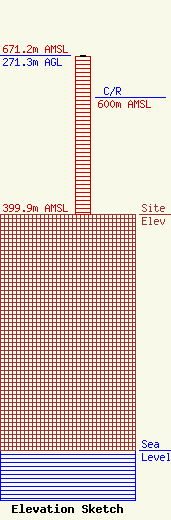
Site Elevation: 399.9 meters (1312 ft) |
| Height of Structure: 268.8 meters (882 feet) |
| Overall Height Above Ground: 271.3 meters (890 feet) |
| Overall Height Above Mean Sea Level: 671.2 meters (2202 feet) |
| C/R Height Above Mean Sea Level: 600 meters (1969 ft)
|
| Owner Info | American Towers LLC
10 Presidential Way
Woburn, MA 01801
(781) 926-4500
faa-fcc@americantower.com |
| Contact Info | American Towers LLC
10 Presidential Way
Woburn, MA 01801
(781) 926-4500
faa-fcc@americantower.com |
