|
|
Antenna Structure Registration 1244826 |
 |
Registration Info | Registration Number: 1244826 |
| File Number: A1121059 |
| FAA Study: 89-AEA-1965-OE |
| FAA Issue Date: 02/12/1990 |
| Status: Constructed |
| Date Constructed: 08/19/2004 |
| NEPA: N |
Structure Info
| Structure Type: LTOWER |
| Structure Coordinates: 40-17-33.2 N 78-15-38.0 W (NAD 83) |
| Structure Coordinates: 40-17-32.9 N 78-15-39.0 W (Converted to NAD 27) |
| Structure Address: 3 Miles Southeast Of Martinsburg |
| Structure City: Martinsburg, PA |
| Structure County: Bedford County |
| Painting & Lighting Info |
FAA Chapters: NONE |
| Elevation Info |
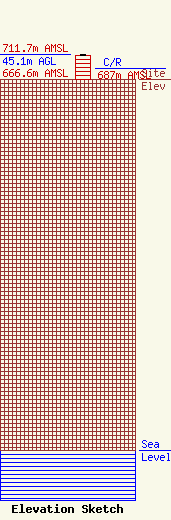
Site Elevation: 666.6 meters (2187 ft) |
| Height of Structure: 42.7 meters (140 feet) |
| Overall Height Above Ground: 45.1 meters (148 feet) |
| Overall Height Above Mean Sea Level: 711.7 meters (2335 feet) |
| C/R Height Above Mean Sea Level: 687 meters (2254 ft)
|
| Owner Info | ComPros, Inc.
400 Highland Avenue
Altoona, PA 16602
(814) 946-8100
zachm@comprosinc.com |
| Contact Info | ComPros, Inc.
400 Highland Avenue
Altoona, PA 16602
Zach Mullen
(814) 946-8100
zachm@comprosinc.com |
