|
|
Antenna Structure Registration 1029997 |
 |
Registration Info | Registration Number: 1029997 |
| File Number: A1127880 |
| FAA Study: 2016-ASW-4876-OE |
| FAA Issue Date: 08/23/2016 |
| Status: Constructed |
| Date Constructed: 01/01/1995 |
| NEPA: N |
Structure Info
| Structure Type: LTOWER |
| Structure Coordinates: 35-29-41.2 N 92-54-0.0 W (NAD 83) |
| Structure Coordinates: 35-29-40.9 N 92-53-59.4 W (Converted to NAD 27) |
| Structure Address: 6726 Nfm 1301 White Mtn Rd (retta Site) |
| Structure City: Hector, AR |
| Structure County: Pope County |
| Painting & Lighting Info |
FAA Circular #: 70/7460-1H |
FAA Chapters: 4, 8, 13 |
Remarks: OM&L to remain the same as prior study = A MED-DUAL SYSTEM |
Remarks: PRIOR STUDY 2004-ASW-1053-OE |
Remarks: OM&L to remain the same as prior study = A MED-DUAL SYSTEM |
Remarks: PRIOR STUDY 2004-ASW-1053-OE |
| Elevation Info |
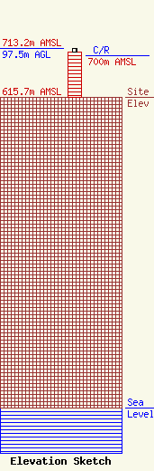
Site Elevation: 615.7 meters (2020 ft) |
| Height of Structure: 91.4 meters (300 feet) |
| Overall Height Above Ground: 97.5 meters (320 feet) |
| Overall Height Above Mean Sea Level: 713.2 meters (2340 feet) |
| C/R Height Above Mean Sea Level: 700 meters (2297 ft)
|
| Owner Info | Alltel Corporation
5055 North Point Pkwy
Alpharetta, GA 30022
(770) 797-1070
Network.Regulatory@verizonwireless.com |
| Contact Info | Alltel Corporation
5055 North Point Pkwy
Alpharetta, GA 30022
Regulatory Manager
(770) 797-1070
Network.Regulatory@verizonwireless.com |
