|
|
Antenna Structure Registration 1282116 |
 |
Registration Info | Registration Number: 1282116 |
| File Number: A1316232 |
| FAA Study: 2025-ANE-1436-OE |
| FAA Issue Date: 06/17/2025 |
| Status: Constructed |
| Date Constructed: 12/30/2011 |
| NEPA: N |
Structure Info
| Structure Type: MTOWER |
| Structure Coordinates: 41-41-6.6 N 71-30-38.1 W (NAD 83) |
| Structure Coordinates: 41-41-06.2 N 71-30-39.9 W (Converted to NAD 27) |
| Structure Address: 226c Cowesett Avenue (374133) |
| Structure City: West Warwick, RI |
| Structure County: Kent County |
| Painting & Lighting Info |
FAA Chapters: NONE |
Remarks: PRIOR STUDY 2021-ANE-7275-OE |
| Elevation Info |
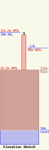
Site Elevation: 62.2 meters (204 ft) |
| Height of Structure: 36.6 meters (120 feet) |
| Overall Height Above Ground: 39 meters (128 feet) |
| Overall Height Above Mean Sea Level: 101.2 meters (332 feet) |
| C/R Height Above Mean Sea Level: 85 meters (279 ft)
|
| Owner Info | American Towers LLC
10 Presidential Way
Woburn, MA 01801
(781) 926-4500
faa-fcc@americantower.com |
| Contact Info | American Towers LLC
10 Presidential Way
Woburn, MA 01801
(781) 926-4500
faa-fcc@americantower.com |
