|
|
Antenna Structure Registration 1000151 |
 |
Registration Info | Registration Number: 1000151 |
| File Number: A0921345 |
| FAA Study: 2014-AGL-2358-OE |
| FAA Issue Date: 06/18/2014 |
| Status: Constructed |
| Date Constructed: 09/01/1990 |
| FAA EMI: N |
| NEPA: N |
Structure Info
| Structure Type: GTOWER |
| Structure Coordinates: 42-4-18.8 N 86-22-15.1 W (NAD 83) |
| Structure Coordinates: 42-04-18.6 N 86-22-15.0 W (Converted to NAD 27) |
| Structure Address: 3634 Townline Rd |
| Structure City: Benton Harbor, MI |
| Structure County: Berrien County |
| Painting & Lighting Info |
FAA Circular #: 70/7460-1K |
FAA Chapters: 4, 6, 12 |
Remarks: PRIOR STUDY 2009-AGL-5623-OE |
Remarks: OM&L to remain the same as prior study = 24-HR MED-STROBES |
Remarks: PRIOR STUDY 2009-AGL-5623-OE |
Remarks: OM&L to remain the same as prior study = 24-HR MED-STROBES |
| Elevation Info |
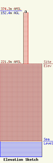
Site Elevation: 221.9 meters (728 ft) |
| Height of Structure: 146.3 meters (480 feet) |
| Overall Height Above Ground: 152.4 meters (500 feet) |
| Overall Height Above Mean Sea Level: 374.3 meters (1228 feet) |
| Owner Info | Mid-West Family Broadcasting of SW Michigan
580 E. Napier Ave
Benton Harbor, MI 49022
(269) 925-1111
golson@wirx.com |
| Contact Info | Mid-West Family Broadcasting of SW Michigan
580 E. Napier Ave
Benton Harbor, MI 49022
Terry Green
(269) 925-1111
tgreen@wirx.com |
