|
|
Antenna Structure Registration 1000403 |
 |
Registration Info | Registration Number: 1000403 |
| File Number: A0635620 |
| FAA Study: 2009-ANM-456-OE |
| FAA Issue Date: 04/02/2009 |
| Status: Granted |
| Date Constructed: 01/01/1969 |
| FAA EMI: N |
| NEPA: N |
Structure Info
| Structure Type: TOWER |
| Structure Coordinates: 44-17-32.8 N 105-26-12.3 W (NAD 83) |
| Structure Coordinates: 44-17-32.9 N 105-26-10.3 W (Converted to NAD 27) |
| Structure Address: 315 Tower Ave |
| Structure City: Gillette, WY |
| Structure County: Campbell County |
| Painting & Lighting Info |
FCC Paragraph(s): 1, 3, 4, 13, 21 |
Remarks: Continue As Is OM&L = PAINT/RED LIGHTS |
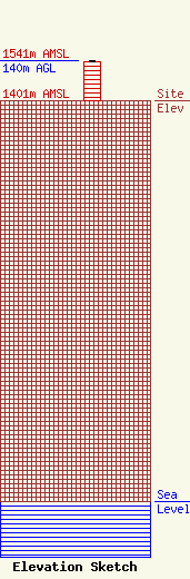
| Elevation Info |
Site Elevation: 1401 meters (4596 ft) |
| Height of Structure: 137 meters (449 feet) |
| Overall Height Above Ground: 140 meters (459 feet) |
| Overall Height Above Mean Sea Level: 1541 meters (5056 feet) |
| Owner Info | Collins Communications Inc.
3795 Collins Rd
GILLETTE, WY 82718
(307) 685-8801
millerst@collinscom.net |
| Contact Info | Collins Communications Inc
3795 Collins Rd
Gillette, WY 82718
Shane Miller
(307) 685-8801
millerst@collinscom.net |
