|
|
Antenna Structure Registration 1000495 |
 |
Registration Info | Registration Number: 1000495 |
| File Number: A1207554 |
| FAA Study: 2020-AGL-18765-OE |
| FAA Issue Date: 10/29/2020 |
| Status: Constructed |
| Date Constructed: 06/15/1985 |
| NEPA: N |
Structure Info
| Structure Type: LTOWER |
| Structure Coordinates: 42-22-39.6 N 83-14-35.1 W (NAD 83) |
| Structure Coordinates: 42-22-39.5 N 83-14-35.4 W (Converted to NAD 27) |
| Structure Address: 12300 Radio Place |
| Structure City: Detroit, MI |
| Structure County: Wayne County |
| Painting & Lighting Info |
FAA Circular #: 70/7460-1L |
FAA Chapters: 4, 8, 12 |
Remarks: PRIOR STUDY 2016-AGL-16087-OE |
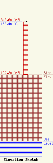
| Elevation Info |
Site Elevation: 190.2 meters (624 ft) |
| Height of Structure: 152.2 meters (499 feet) |
| Overall Height Above Ground: 152.4 meters (500 feet) |
| Overall Height Above Mean Sea Level: 342.6 meters (1124 feet) |
| Owner Info | WMUZ RADIO INC
3003
BLUE BELL, PA 19422
(215) 628-3500
towers@crawfordbroadcasting.com |
| Contact Info | Crawford Broadcasting Company
2821 S. Parker Road
Aurora, CO 80014
Cris Alexander
(303) 433-0104
crisa@crawfordbroadcasting.com |
