|
|
Antenna Structure Registration 1000629 |
 |
Registration Info | Registration Number: 1000629 |
| File Number: A1379202 |
| FAA Study: 80-GL-1353-OE |
| Status: Constructed |
| Date Constructed: 01/01/1981 |
| NEPA: N |
Structure Info
|
| Structure Coordinates: 44-43-16.0 N 85-42-13.0 W (NAD 83) |
| Structure Coordinates: 44-43-16.0 N 85-42-12.7 W (Converted to NAD 27) |
| Structure Address: Secor Rd 8 Km Sw |
| Structure City: Traverse City, MI |
| Structure County: Grand Traverse County |
| Painting & Lighting Info |
FCC Paragraph(s): 1, 3, 12, 21 |
| Elevation Info |
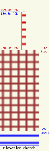
Site Elevation: 278.9 meters (915 ft) |
| Height of Structure: 130 meters (427 feet) |
| Overall Height Above Ground: 130.8 meters (429 feet) |
| Overall Height Above Mean Sea Level: 409.7 meters (1344 feet) |
| Owner Info | WTCM RADIO INC
314 E FRONT ST
TRAVERSE CITY, MI 49684
(231) 947-7675
chrisw@wtcmradio.com |
| Contact Info | WTCM RADIO INC
314 E. FRONT ST.
Traverse City, MI 49684
Eric Send
(231) 947-7675
erics@wtcmradio.com |
