|
|
Antenna Structure Registration 1000688 |
 |
Registration Info | Registration Number: 1000688 |
| File Number: A1379291 |
| FAA Study: 2026-AGL-4054-OE |
| FAA Issue Date: 03/10/2026 |
| Status: Constructed |
| Date Constructed: 07/11/1961 |
| NEPA: N |
Structure Info
| Structure Type: GTOWER |
| Structure Coordinates: 42-37-55.4 N 85-32-15.7 W (NAD 83) |
| Structure Coordinates: 42-37-55.3 N 85-32-15.6 W (Converted to NAD 27) |
| Structure Address: 6 Mi Se |
| Structure City: Wayland, MI |
| Structure County: Barry County |
| Painting & Lighting Info |
FAA Circular #: 70/7460-1M |
FAA Chapters: 3, 4, 5, 15 |
Remarks: PRIOR STUDY 2026-AGL-4051-OE |
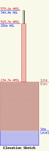
| Elevation Info |
Site Elevation: 234.7 meters (770 ft) |
| Height of Structure: 281 meters (922 feet) |
| Overall Height Above Ground: 344.4 meters (1130 feet) |
| Overall Height Above Mean Sea Level: 579.1 meters (1900 feet) |
| Owner Info | WWMT Licensee, LLC
Pillsbury Winthrop Shaw Pittman LLP
Washington, DC 20036
(202) 663-8195
miles.mason@pillsburylaw.com |
| Contact Info | Micronet Communications, Inc.
2000 N Central Expressway
Plano, TX 75074
(972) 422-7200
regulatory@micronetcom.com |
