|
|
Antenna Structure Registration 1000700 |
 |
Registration Info | Registration Number: 1000700 |
| File Number: A1358778 |
| FAA Study: 97-AGL-0145-OE |
| FAA Issue Date: 02/04/1997 |
| Status: Constructed |
| Date Constructed: 06/30/1995 |
| FAA EMI: N |
| NEPA: N |
Structure Info
| Structure Type: TOWER |
| Structure Coordinates: 45-40-0.0 N 84-38-5.0 W (NAD 83) |
| Structure Coordinates: 45-39-60.0 N 84-38-04.8 W (Converted to NAD 27) |
| Structure Address: Douglas Rd |
| Structure City: Cheboygan, MI |
| Structure County: Cheboygan County |
| Painting & Lighting Info |
FAA Circular #: 70/7460-1J |
FAA Chapters: 3, 4, 5, 13 |
| Elevation Info |
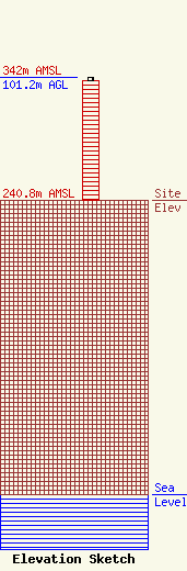
Site Elevation: 240.8 meters (790 ft) |
| Height of Structure: 98 meters (322 feet) |
| Overall Height Above Ground: 101.2 meters (332 feet) |
| Overall Height Above Mean Sea Level: 342 meters (1122 feet) |
| Owner Info | K2 Towers III, LLC
57 E Washington Street
Chagrin Falls, OH 44022
(866) 962-0904
rlepene@peppertreecapital.com |
| Contact Info | K2 Towers III, LLC
57 E Washington Street
Chagrin Falls, OH 44022
Greg Thompson
(866) 962-0904
gthompson@k2towers.com |
