|
|
Antenna Structure Registration 1000707 |
 |
Registration Info | Registration Number: 1000707 |
| File Number: A0507708 |
| FAA Study: 2004-AEA-3229-OE |
| FAA Issue Date: 12/08/2004 |
| Status: Constructed |
| Date Constructed: 05/02/1996 |
| FAA EMI: N |
| NEPA: N |
Structure Info
| Structure Type: TOWER |
| Structure Coordinates: 40-59-16.1 N 76-32-49.5 W (NAD 83) |
| Structure Coordinates: 40-59-15.8 N 76-32-50.7 W (Converted to NAD 27) |
| Structure Address: Montour Ridge |
| Structure City: Danville, PA |
| Structure County: Columbia County |
| Painting & Lighting Info |
FCC Paragraph(s): A1, H, 3, 11, 21, 23 |
Remarks: Continue As Is OM&L = A MED-DUAL SYSTEM |
Remarks: PRIOR STUDY 1997-AEA-2197-OE |
| Elevation Info |
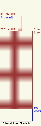
Site Elevation: 387.1 meters (1270 ft) |
| Height of Structure: 73.5 meters (241 feet) |
| Overall Height Above Ground: 74.4 meters (244 feet) |
| Overall Height Above Mean Sea Level: 461.5 meters (1514 feet) |
| Owner Info | MONTROSE BROADCASTING CORPORATION
8 EAST MARKET STREET
DANVILLE, PA 17821
(570) 275-1570
apel@epix.net |
