|
|
Antenna Structure Registration 1002162 |
 |
Registration Info | Registration Number: 1002162 |
| File Number: A1050698 |
| FAA Study: 75-GL-625-OE |
| FAA Issue Date: 05/20/1975 |
| Status: Constructed |
| Date Constructed: 01/01/1975 |
| NEPA: N |
Structure Info
| Structure Type: TOWER |
| Structure Coordinates: 44-17-58.0 N 84-23-43.0 W (NAD 83) |
| Structure Coordinates: 44-17-57.9 N 84-23-43.0 W (Converted to NAD 27) |
| Structure Address: 3 Mi S |
| Structure City: Saint Helen, MI |
| Structure County: Roscommon County |
| Painting & Lighting Info |
FCC Paragraph(s): 1, 3, 12, 21 |
Remarks: RED LIGHTS/PAINT |
| Elevation Info |
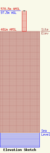
Site Elevation: 481 meters (1578 ft) |
| Height of Structure: 97 meters (318 feet) |
| Overall Height Above Ground: 97.5 meters (320 feet) |
| Overall Height Above Mean Sea Level: 578.5 meters (1898 feet) |
| Owner Info | CMU Public Broadcasting
1999 East Campus Drive
Mt. Pleasant, MI 48859
(989) 774-3105
wayne.h@cmich.edu |
| Contact Info | CMU Public Broadcasting
1999 East Campus Drive
Mt. Pleasant, MI 48859
(989) 774-3105
wayne.h@cmich.edu |
