|
|
Antenna Structure Registration 1002464 |
 |
Registration Info | Registration Number: 1002464 |
| File Number: A1382118 |
| FAA Study: 2026-AGL-2408-OE |
| FAA Issue Date: 03/10/2026 |
| Status: Constructed |
| Date Constructed: 12/22/2008 |
| NEPA: N |
Structure Info
| Structure Type: GTOWER |
| Structure Coordinates: 42-28-14.7 N 83-14-59.3 W (NAD 83) |
| Structure Coordinates: 42-28-14.6 N 83-14-59.6 W (Converted to NAD 27) |
| Structure Address: 20777 W Ten Mile Rd |
| Structure City: Southfield, MI |
| Structure County: Oakland County |
| Painting & Lighting Info |
FCC Paragraph(s): 1, 3, 8, 17, 21 |
Remarks: Continue As Is OM&L = PAINT/RED LIGHTS |
Remarks: PRIOR STUDY 2010-AGL-6244-OE |
Remarks: Continue As Is OM&L = PAINT/RED LIGHTS |
Remarks: PRIOR STUDY 2010-AGL-6244-OE |
| Elevation Info |
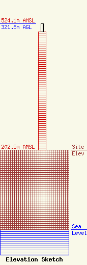
Site Elevation: 202.5 meters (664 ft) |
| Height of Structure: 301.5 meters (989 feet) |
| Overall Height Above Ground: 321.6 meters (1055 feet) |
| Overall Height Above Mean Sea Level: 524.1 meters (1719 feet) |
| Owner Info | Scripps Broadcasting Holdings LLC
312 Walnut Street
Cincinnati, OH 45202
(513) 977-3000
Bianca.Frye@scripps.com |
| Contact Info | The E.W. Scripps Company
312 Walnut Street
Cincinnati, OH 45202
David Giles
(513) 977-3000
David.Giles@scripps.com |
