|
|
Antenna Structure Registration 1002511 |
 |
Registration Info | Registration Number: 1002511 |
| File Number: A1297264 |
| FAA Study: 96-AGL-2486-OE |
| FAA Issue Date: 08/19/1996 |
| Status: Constructed |
| Date Constructed: 01/01/1958 |
| FAA EMI: N |
| NEPA: N |
Structure Info
| Structure Type: TOWER |
| Structure Coordinates: 43-0-30.0 N 83-39-56.0 W (NAD 83) |
| Structure Coordinates: 43-00-29.9 N 83-39-56.2 W (Converted to NAD 27) |
| Structure Address: 2302 Lapeer Rd |
| Structure City: Flint, MI |
| Structure County: Genesee County |
| Painting & Lighting Info |
FCC Paragraph(s): 1, 3, 11, 21 |
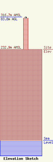
| Elevation Info |
Site Elevation: 232.9 meters (764 ft) |
| Height of Structure: 80.3 meters (263 feet) |
| Overall Height Above Ground: 83.8 meters (275 feet) |
| Overall Height Above Mean Sea Level: 316.7 meters (1039 feet) |
| Owner Info | Gray Local Media, Inc.
4370 Peachtree Road, NE
Atlanta, GA 30319
(404) 266-8333
legalnotices@graymedia.com |
| Contact Info | Gray Local Media, Inc.
4370 Peachtree Road NE
Atlanta, GA 30319
Engineering Department
(404) 266-8333
legalnotices@graymedia.com |
