|
|
Antenna Structure Registration 1002839 |
 |
Registration Info | Registration Number: 1002839 |
| File Number: A1329195 |
| FAA Study: 2025-ASW-8435-OE |
| FAA Issue Date: 07/22/2025 |
| Status: Constructed |
| Date Constructed: 01/01/1970 |
| NEPA: N |
Structure Info
| Structure Type: GTOWER |
| Structure Coordinates: 32-41-52.1 N 103-33-20.2 W (NAD 83) |
| Structure Coordinates: 32-41-51.7 N 103-33-18.4 W (Converted to NAD 27) |
| Structure Address: Gemini Lane Approximately 27 Miles West Of Hobbs (mescalero Ridge (cc) 208136) |
| Structure City: Hobbs, NM |
| Structure County: Lea County |
| Painting & Lighting Info |
FCC Paragraph(s): 1, 3, 12, 21 |
Remarks: Continue As Is OM&L = PAINT/RED LIGHTS |
| Elevation Info |
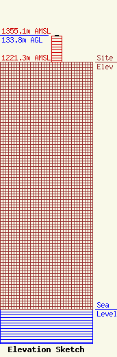
Site Elevation: 1221.3 meters (4007 ft) |
| Height of Structure: 131.1 meters (430 feet) |
| Overall Height Above Ground: 133.8 meters (439 feet) |
| Overall Height Above Mean Sea Level: 1355.1 meters (4446 feet) |
| Owner Info | American Towers LLC
10 Presidential Way
Woburn, MA 01801
(781) 926-4500
faa-fcc@americantower.com |
| Contact Info | American Towers LLC
10 Presidential Way
Woburn, MA 01801
(781) 926-4500
faa-fcc@americantower.com |
