|
|
Antenna Structure Registration 1002863 |
 |
Registration Info | Registration Number: 1002863 |
| File Number: A1129526 |
| FAA Study: 2017-ASO-1003-OE |
| FAA Issue Date: 02/15/2017 |
| Status: Constructed |
| Date Constructed: 02/21/1994 |
| NEPA: N |
Structure Info
| Structure Type: GTOWER |
| Structure Coordinates: 31-11-40.0 N 81-29-30.3 W (NAD 83) |
| Structure Coordinates: 31-11-39.2 N 81-29-30.9 W (Converted to NAD 27) |
| Structure Address: 231 Rose Dr |
| Structure City: Brunswick, GA |
| Structure County: Glynn County |
| Painting & Lighting Info |
FAA Circular #: 70/7460-1L |
FAA Chapters: 3, 4, 5, 12 |
Remarks: PRIOR STUDY 1993-ASO-1072-OE |
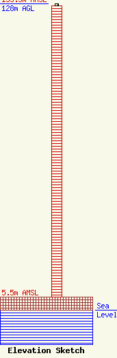
| Elevation Info |
Site Elevation: 5.5 meters (18 ft) |
| Height of Structure: 127.1 meters (417 feet) |
| Overall Height Above Ground: 128 meters (420 feet) |
| Overall Height Above Mean Sea Level: 133.5 meters (438 feet) |
| Owner Info | GIQ, LLC
205 Marina Drive
St. Simons Island, GA 31522
(912) 634-6575
eddie@eddieesserman.com |
| Contact Info | GIQ, LLC
205 Marina Drive
St. Simons Island, GA 31522
Edward Esserman
(912) 634-6575
eddie@eddieesserman.com |
