|
|
Antenna Structure Registration 1003137 |
 |
Registration Info | Registration Number: 1003137 |
| File Number: A0003554 |
| FAA Study: 95-AGL-1568-OE |
| Status: Constructed |
| Date Constructed: 06/01/1995 |
| NEPA: N |
Structure Info
| Structure Type: TOWER |
| Structure Coordinates: 39-5-37.0 N 84-53-3.0 W (NAD 83) |
| Structure Coordinates: 39-05-36.8 N 84-53-03.2 W (Converted to NAD 27) |
| Structure Address: 20 Wolf Run Rd |
| Structure City: Lawrenceburg, IN |
| Structure County: Dearborn County |
| Painting & Lighting Info |
FAA Circular #: 70/7460-1H |
FAA Chapters: 3, 4, 5, 13 |
| Elevation Info |
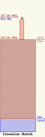
Site Elevation: 240.8 meters (790 ft) |
| Height of Structure: 60.9 meters (200 feet) |
| Overall Height Above Ground: 67 meters (220 feet) |
| Overall Height Above Mean Sea Level: 307.8 meters (1010 feet) |
| Owner Info | SCHULER, JOHN W
6859 SALEM RDIGE RD
AURORA, IN 47001
(812) 438-2000
|
