|
|
Antenna Structure Registration 1003149 |
 |
Registration Info | Registration Number: 1003149 |
| File Number: A1131691 |
| FAA Study: 92-AEA-1277-OE |
| Status: Constructed |
| Date Constructed: 05/01/1983 |
| NEPA: N |
Structure Info
| Structure Type: TOWER |
| Structure Coordinates: 42-20-7.0 N 77-27-26.0 W (NAD 83) |
| Structure Coordinates: 42-20-06.7 N 77-27-27.1 W (Converted to NAD 27) |
| Structure Address: On Turnpike Rd 7 Mi W Of Bath |
| Structure City: Howard, NY |
| Structure County: Steuben County |
| Painting & Lighting Info |
FCC Paragraph(s): 1, 3, 11, 21 |
| Elevation Info |
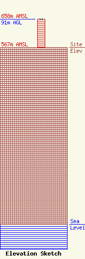
Site Elevation: 567 meters (1860 ft) |
| Height of Structure: 91 meters (299 feet) |
| Overall Height Above Ground: 91 meters (299 feet) |
| Overall Height Above Mean Sea Level: 658 meters (2159 feet) |
| Owner Info | ATS HOLDINGS, LLC
1300 COLLEGE AVE
1237
ELMIRA, NY 14902
(607) 271-9770
ats@bricotech.com |
| Contact Info | ATS HOLDINGS, LLC
1300 COLLEGE AVE
1237
ELMIRA, NY 14902
BRIAN ADAMS
(607) 271-9770
ats@bricotech.com |
