|
|
Antenna Structure Registration 1003207 |
 |
Registration Info | Registration Number: 1003207 |
| File Number: A0979012 |
| FAA Study: 2011-AAL-58-OE |
| FAA Issue Date: 03/04/2011 |
| Status: Constructed |
| Date Constructed: 03/18/2011 |
| FAA EMI: N |
| NEPA: N |
Structure Info
| Structure Type: TOWER |
| Structure Coordinates: 59-45-19.3 N 151-46-24.4 W (NAD 83) |
| Structure Coordinates: 59-45-21.5 N 151-46-16.6 W (Converted to NAD 27) |
| Structure Address: E Of Sterling Hwy At Mile 160 |
| Structure City: Anchor Point, AK |
| Structure County: Kenai Peninsula Borough |
| Painting & Lighting Info |
FAA Circular #: 70/7460-1K |
FAA Chapters: 4, 8, 12 |
Remarks: OM&L to remain the same as prior study = A MED-DUAL SYSTEM |
Remarks: PRIOR STUDY 2003-AAL-22-OE |
Remarks: OM&L to remain the same as prior study = A MED-DUAL SYSTEM |
Remarks: PRIOR STUDY 2003-AAL-22-OE |
| Elevation Info |
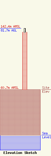
Site Elevation: 60.7 meters (199 ft) |
| Height of Structure: 76.2 meters (250 feet) |
| Overall Height Above Ground: 81.7 meters (268 feet) |
| Overall Height Above Mean Sea Level: 142.4 meters (467 feet) |
| Owner Info | State of Alaska
5900 East Tudor Road
Anchorage, AK 99507
(907) 269-5744
FccLicenseManager@alaska.gov |
| Contact Info | State of Alaska
5900 East Tudor Road
Anchorage, AK 99507
FCC License Manager
(907) 269-5744
FccLicenseManager@alaska.gov |
