|
|
Antenna Structure Registration 1003235 |
 |
Registration Info | Registration Number: 1003235 |
| File Number: A1122799 |
| FAA Study: 00-ASO-0241-OE |
| FAA Issue Date: 01/19/2000 |
| Status: Constructed |
| Date Constructed: 09/18/2014 |
| NEPA: N |
Structure Info
| Structure Type: LTOWER |
| Structure Coordinates: 35-16-21.0 N 80-45-53.0 W (NAD 83) |
| Structure Coordinates: 35-16-20.5 N 80-45-53.7 W (Converted to NAD 27) |
| Structure Address: 232 Heathway Dr |
| Structure City: Charlotte, NC |
| Structure County: Mecklenburg County |
| Painting & Lighting Info |
FAA Circular #: 70/7460-1J |
FAA Chapters: 3, 4, 5, 13 |
Remarks: PRIOR FAA 96-ASO-3984-OE |
| Elevation Info |
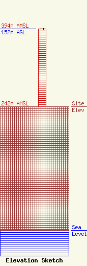
Site Elevation: 242 meters (794 ft) |
| Height of Structure: 152 meters (499 feet) |
| Overall Height Above Ground: 152 meters (499 feet) |
| Overall Height Above Mean Sea Level: 394 meters (1293 feet) |
| Owner Info | Charlotte, City of
527 Spratt Street
Charlotte, NC 28206
(704) 336-5810
jfinger@charlottenc.gov |
| Contact Info | New Wave Licensing Services, Inc.
818 Taneytown Rd.
Gettysburg, PA 17325
Rob Dayhoff
(717) 334-0910
rfdayhoff@gmail.com |
