|
|
Antenna Structure Registration 1003306 |
 |
Registration Info | Registration Number: 1003306 |
| File Number: A0786755 |
| FAA Study: 96-AGL-2632-OE |
| FAA Issue Date: 08/26/1996 |
| Status: Constructed |
| Date Constructed: 06/01/1997 |
| FAA EMI: N |
| NEPA: N |
Structure Info
| Structure Type: TOWER |
| Structure Coordinates: 44-27-43.0 N 96-10-27.0 W (NAD 83) |
| Structure Coordinates: 44-27-43.1 N 96-10-25.9 W (Converted to NAD 27) |
| Structure Address: On Hwy 19 3.6 Mi E |
| Structure City: Ivanhoe, MN |
| Structure County: Lincoln County |
| Painting & Lighting Info |
FAA Circular #: 70/7460-1J |
FAA Chapters: 3, 4, 5, 13 |
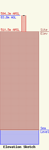
| Elevation Info |
Site Elevation: 510.5 meters (1675 ft) |
| Height of Structure: 82.8 meters (272 feet) |
| Overall Height Above Ground: 83.8 meters (275 feet) |
| Overall Height Above Mean Sea Level: 594.3 meters (1950 feet) |
| Owner Info | WEST CENTRAL MN EDUC TV CO INC
120 W SCHLIEMAN
APPLETON, MN 56208
(320) 289-2622
|
