|
|
Antenna Structure Registration 1003343 |
 |
Registration Info | Registration Number: 1003343 |
| File Number: A1063895 |
| FAA Study: 88-ASW-1039-OE |
| FAA Issue Date: 08/10/1988 |
| Status: Constructed |
| Date Constructed: 09/09/1968 |
| FAA EMI: N |
| NEPA: N |
Structure Info
| Structure Type: TOWER |
| Structure Coordinates: 34-26-25.0 N 103-12-39.0 W (NAD 83) |
| Structure Coordinates: 34-26-24.7 N 103-12-37.2 W (Converted to NAD 27) |
| Structure Address: Approx 3.2 Km N |
| Structure City: Clovis, NM |
| Structure County: Curry County |
| Painting & Lighting Info |
FAA Circular #: 70/7460-1G |
FAA Chapters: 3, 4, 5, 9 |
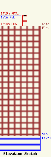
| Elevation Info |
Site Elevation: 1314 meters (4311 ft) |
| Height of Structure: 119 meters (390 feet) |
| Overall Height Above Ground: 125 meters (410 feet) |
| Overall Height Above Mean Sea Level: 1439 meters (4721 feet) |
| Owner Info | KVII Licensee, LLC
Pillsbury Winthrop Shaw Pittman LLP
Washington, DC 20036
(202) 663-8195
miles.mason@pillsburylaw.com |
| Contact Info | KVII Licensee, LLC
Pillsbury Winthrop Shaw Pittman LLP
Washington, DC 20036
(202) 663-8195
miles.mason@pillsburylaw.com |
