|
|
Antenna Structure Registration 1003384 |
 |
Registration Info | Registration Number: 1003384 |
| File Number: A1262493 |
| FAA Study: 2023-AEA-14508-OE |
| FAA Issue Date: 12/04/2023 |
| Status: Constructed |
| Date Constructed: 09/09/2016 |
Structure Info
| Structure Type: GTOWER |
| Structure Coordinates: 44-34-27.3 N 73-40-29.0 W (NAD 83) |
| Structure Coordinates: 44-34-27.1 N 73-40-30.5 W (Converted to NAD 27) |
| Structure Address: Terry Mtn 7.3 Mi W |
| Structure City: Peru, NY |
| Structure County: Clinton County |
| Painting & Lighting Info |
FAA Circular #: 70/7460-1M |
FAA Chapters: 4, 9, 15 |
Remarks: PRIOR STUDY 2015-AEA-2856-OE |
| Elevation Info |
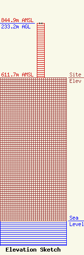
Site Elevation: 611.7 meters (2007 ft) |
| Height of Structure: 233 meters (764 feet) |
| Overall Height Above Ground: 233.2 meters (765 feet) |
| Overall Height Above Mean Sea Level: 844.9 meters (2772 feet) |
| Owner Info | County of Essex
7551 Court St.
217
Elizabethtown, NY 12932
(518) 873-3333
michael.mascarenas@essexcountyny.gov |
| Contact Info | Essex County Emergency Services
702 Stowersville Rd.
Lewis, NY 12950
Matthew Watts
(518) 873-3900
matthew.watts@essexcountyny.gov |
