|
|
Antenna Structure Registration 1003449 |
 |
Registration Info | Registration Number: 1003449 |
| File Number: A1108710 |
| FAA Study: 2018-ASW-2774-OE |
| FAA Issue Date: 05/09/2018 |
| Status: Constructed |
| Date Constructed: 07/01/1996 |
| NEPA: N |
Structure Info
| Structure Type: GTOWER |
| Structure Coordinates: 36-20-55.6 N 92-24-1.1 W (NAD 83) |
| Structure Coordinates: 36-20-55.4 N 92-24-00.5 W (Converted to NAD 27) |
| Structure Address: Skyline Drive (204450) |
| Structure City: Mountain Home, AR |
| Structure County: Baxter County |
| Painting & Lighting Info |
FAA Circular #: 70/7460-1L |
FAA Chapters: 4, 8, 12 |
Remarks: PRIOR STUDY 1996-ASW-327-OE |
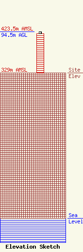
| Elevation Info |
Site Elevation: 329 meters (1079 ft) |
| Height of Structure: 90 meters (295 feet) |
| Overall Height Above Ground: 94.5 meters (310 feet) |
| Overall Height Above Mean Sea Level: 423.5 meters (1389 feet) |
| Owner Info | American Towers LLC
10 Presidential Way
Woburn, MA 01801
(781) 926-4500
faa-fcc@americantower.com |
| Contact Info | American Towers, LLC
10 Presidential Way
Woburn, MA 01801
(781) 926-4500
faa-fcc@americantower.com |
