|
|
Antenna Structure Registration 1003450 |
 |
Registration Info | Registration Number: 1003450 |
| File Number: A1199055 |
| FAA Study: 2016-AGL-12920-OE |
| FAA Issue Date: 05/02/2017 |
| Status: Constructed |
| Date Constructed: 10/10/1981 |
Structure Info
| Structure Type: LTOWER |
| Structure Coordinates: 43-10-31.9 N 83-4-2.4 W (NAD 83) |
| Structure Coordinates: 43-10-31.8 N 83-04-02.6 W (Converted to NAD 27) |
| Structure Address: 2.5 Mi S |
| Structure City: Burnside, MI |
| Structure County: Lapeer County |
| Painting & Lighting Info |
FAA Circular #: 70/7460-1L |
FAA Chapters: 4, 8, 12 |
| Elevation Info |
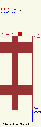
Site Elevation: 303.6 meters (996 ft) |
| Height of Structure: 105.2 meters (345 feet) |
| Overall Height Above Ground: 105.2 meters (345 feet) |
| Overall Height Above Mean Sea Level: 408.8 meters (1341 feet) |
| Owner Info | THUMB RADIO INC
1020 N Van Dyke
1020 N Van Dyke
Bad Axe, MI 48413
(989) 269-6420
thumbrad@airadv.net |
| Contact Info | Thumb Radio Inc
1020 N. Van Dyke
Bad Axe, MI 48413
Mary Robinson
(989) 269-6420
thumbrad@airadv.net |
