|
|
Antenna Structure Registration 1003524 |
 |
Registration Info | Registration Number: 1003524 |
| File Number: A1063779 |
| FAA Study: 87-ACE-0863-OE |
| FAA Issue Date: 01/15/1988 |
| Status: Constructed |
| Date Constructed: 01/01/1948 |
| FAA EMI: N |
| NEPA: N |
Structure Info
| Structure Type: TOWER |
| Structure Coordinates: 38-38-9.0 N 90-11-45.0 W (NAD 83) |
| Structure Coordinates: 38-38-08.8 N 90-11-44.6 W (Converted to NAD 27) |
| Structure Address: 1215 Cole St |
| Structure City: Saint Louis, MO |
| Structure County: St. Louis city |
| Painting & Lighting Info |
FAA Circular #: 70/7460-1G |
FAA Chapters: 3, 4, 5, 9 |
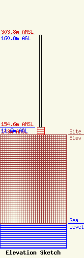
| Elevation Info |
Site Elevation: 143 meters (469 ft) |
| Height of Structure: 11.6 meters (38 feet) |
| Overall Height Above Ground: 160.8 meters (528 feet) |
| Overall Height Above Mean Sea Level: 303.8 meters (997 feet) |
| Owner Info | KDNL Licensee, LLC
Pillsbury Winthrop Shaw Pittman LLP
Washington, DC 20036
(202) 663-8195
miles.mason@pillsburylaw.com |
| Contact Info | KDNL Licensee, LLC
Pillsbury Winthrop Shaw Pittman LLP
Washington, DC 20036
(202) 663-8195
miles.mason@pillsburylaw.com |
