|
|
Antenna Structure Registration 1003616 |
 |
Registration Info | Registration Number: 1003616 |
| File Number: A0568062 |
| FAA Study: 2004-AEA-1029-OE |
| FAA Issue Date: 04/16/2004 |
| Status: Constructed |
| Date Constructed: 09/03/2003 |
| FAA EMI: N |
| NEPA: N |
Structure Info
| Structure Type: TOWER |
| Structure Coordinates: 42-59-31.6 N 74-54-53.3 W (NAD 83) |
| Structure Coordinates: 42-59-31.3 N 74-54-54.8 W (Converted to NAD 27) |
| Structure Address: 500' S. Of Highest Point On Shoemaker Hill |
| Structure City: Mohawk, NY |
| Structure County: Herkimer County |
| Painting & Lighting Info |
FAA Chapters: NONE |
Remarks: PRIOR STUDY 2003-AEA-3673-OE |
| Elevation Info |
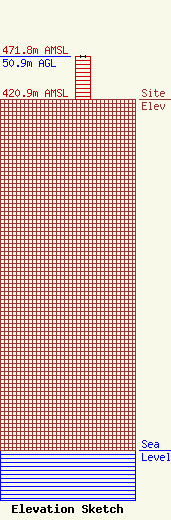
Site Elevation: 420.9 meters (1381 ft) |
| Height of Structure: 50.9 meters (167 feet) |
| Overall Height Above Ground: 50.9 meters (167 feet) |
| Overall Height Above Mean Sea Level: 471.8 meters (1548 feet) |
| Owner Info | Roser Communications Network, inc.
185 Gennessee Street
Utica, NY 13501
(315) 734-9245
|
| Info |
