|
|
Antenna Structure Registration 1003617 |
 |
Registration Info | Registration Number: 1003617 |
| File Number: A0004139 |
| FAA Study: 90-AEA-0043-OE |
| FAA Issue Date: 02/23/1990 |
| Status: Constructed |
| Date Constructed: 05/01/1990 |
| NEPA: N |
Structure Info
| Structure Type: TOWER |
| Structure Coordinates: 42-52-44.0 N 74-47-6.0 W (NAD 83) |
| Structure Coordinates: 42-52-43.7 N 74-47-07.5 W (Converted to NAD 27) |
| Structure Address: .21 Km Nw From Int Rts 204 & 95 |
| Structure City: Starkville, NY |
| Structure County: Herkimer County |
| Painting & Lighting Info |
FAA Circular #: 70/7460-1G |
FAA Chapters: 3, 4, 5, 9 |
| Elevation Info |
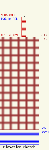
Site Elevation: 481.6 meters (1580 ft) |
| Height of Structure: 106 meters (348 feet) |
| Overall Height Above Ground: 106.4 meters (349 feet) |
| Overall Height Above Mean Sea Level: 587.9 meters (1929 feet) |
| Owner Info | ROSER COMMUNICATION NETWORK INC
4490
UTICA, NY 13504
(315) 797-9797
|
